четвер, 11 жовтня 2012 р.
Geography
The Land
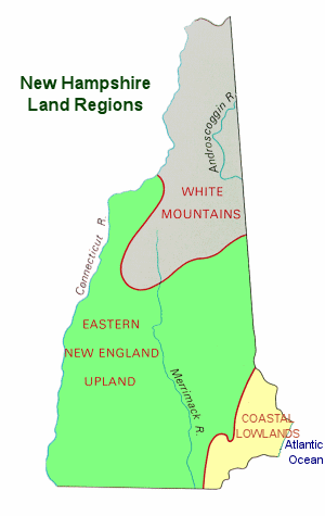
Known for its natural beauty, New Hamsphire features rugged mountains, clear blue lakes, and sandy lake and ocean beaches. All of these features are packed into one of the smallest states of the 50 states. New Hampshire ranks 46th in terms of size; 9,351 square miles. Contained within the Appalachian Highlands, the three primary geological features and landforms (physiographic regions) of New Hampshire are; the Coastal Lowlands, the Eastern New England Upland, and the White Mountain Region.
The Coastal Lowlands
The Coastal Lowlands characterize the southeastern section of the state where New Hampshire borders the Atlantic Ocean. With only 13 miles of coastline, the New Hampshire coastline is shorter than any other state that borders an ocean. The Coastal Lowlands extend from 15 to 20 miles into New Hamsphire. Sandy beaches line the coast and rivers and tidal wetlands extend inland. Great Bay is part of the Coastal Lowlands and thousands of waterfowl stop at the bay during their annual migrations.
The Eastern New England Upland
Most of southern New Hampshire is covered by the Eastern New England Upland, the region that runs from northern Maine south to eastern Connecticut. The New Hampshire section is comprised of 3 distinct areas; the Merrimack Valley, the Hills and Lakes Region, and the Connecticut River Valley.
The Merrimack Valley extends from the Massachusetts border north to central New Hampshire. The Merrimack River runs through this hilly landscape. The soil is fertile and fruits and hay are grown in this region. The valley is also home to New Hampshire's most prominent mill and factory cities and towns.The Hills and Lakes region wraps around the Merrimack Valley region on the east, the north, and the west; from the border of Maine arcing northwest and then south almost reaching the border of Vermont. This area contains most of New Hampshire's major lakes, including its largest; Lake Winnipesaukee.
The Connecticut River Valley extends from north to south along the Connecticut River, New Hampshire's border with Vermont. The lowlands are comprised of fertile farmland and the hills are covered with hardwood forests.
The White Mountains
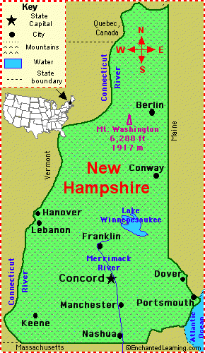
The White Mountains Region, north of the Eastern New England Upland, covers the northern portion of the state and consists of rugged mountains and narrow valleys. Mount Washington, the highest point in New Hamsphire and the highest point in New England, is part of the Presidential Range. It is 6,288 feet above sea level and home to some of the worst weather in the world. Five other peaks in the Presidential Range are over a mile in height. The Franconia Range includes Profile Mountain which formerly hosted theOld Man of the Mountain, a granite profile of an old man's face, near the peak.
The most northern portion of the region is characterized by heavily forested hills. The western section is populated with dairy and potato farms.Climate
Climate
New Hampshire experiences a humid continental climate (Koppen climate classification Dfa in southern areas and Dfb in the north), with warm, humid summers, cold, wet winters, and uniform precipitation all year. The climate of the southeastern portion is moderated by the Atlantic Ocean and averages relatively milder and wetter weather, while the northern and interior portions experience cooler temperatures and lower humidity. Winters are cold and snowy throughout the state, and especially severe in the northern and mountainous areas. Average annual snowfall ranges from 60 inches (150 cm) to over 100 inches (250 cm) across the state.
Average daytime highs are in the mid 70s°F to low 80s°F (around 24-28 °C) throughout the state in July, with overnight lows in the mid 50s°F to low 60s°F (13-15 °C). January temperatures range from an average high of 34 °F (1 °C) on the coast to overnight lows below 0 °F (-18 °C) in the far north and at high elevations. Average annual precipitation statewide is roughly 40 inches (100 cm) with some variation occurring in the White Mountains due to differences in elevation and annual snowfall.
Extreme snow is often associated with a nor'easter, such as the Blizzard of '78 and the Blizzard of 1993, when several feet accumulated across portions of the state over 24 to 48 hours. Lighter snowfall of several inches occur frequently throughout winter, often associated with an Alberta Clipper.
New Hampshire, on occasion, is affected by hurricanes and tropical storms although by the time they reach the state they are often extratropical, with most storms striking the southern New England coastline and moving inland or passing by offshore in the Gulf of Maine. Most of New Hampshire averages fewer than 20 days of thunderstorms per year and an average of 2 tornadoes occur annually statewide
The National Arbor Day Foundation plant hardiness zone map depicts zones 3, 4, 5, and 6 occurring throughout the state and indicates the transition from a relatively cooler to warmer climate as one travels southward across New Hampshire.Regoins of New Hampshire
ABOUT THE REGIONS
New Hampshire is made up of seven very different regions, each as exciting as the next. The Seacoast, Dartmouth-Lake Sunapee, Lakes Region, Merrimack Valley, Monadnock Region, White Mountains and Great North Woods are filled with natural beauty, cultural events and classic New England living.
It's one family vacation idea after another, and the only way to truly appreciate it all is to see it for yourself. Use the list at left to learn more about each of New Hampshire's distinct, yet equally unforgettable, regions.
Various Algonquian (Pennacook) tribes inhabited the area prior to European settlement. English and French explorers visited New Hampshire in 1600–1605, and English fishermen settled at Odiorne's Point in present-day Rye in 1623. The first permanent settlement was at Hilton's Point (present-day Dover). By 1631, the Upper Plantation comprised modern-day Dover, Durham and Stratham; in 1679, it became the "Royal Province."
Since 1952, New Hampshire gained national and international attention for its presidential primary held early in every presidential election year. It immediately became the most important testing grounds for candidates for the Republican and Democratic nominations. The media gave New Hampshire (and Iowa) about half of all the attention paid to all states in the primary process, magnifying the state's decision
powers (and spurring repeated efforts by out-of-state politicians to change the rules.)
New Hampshire (main information)
 |
| Flag fo New Hampshire |
 |
| Map of New Hampshire |
New Hampshire is astate in the New England region of the northeastern United States of America. The state was named after the southern English county of Hampshire. It is bordered by Massachusetts to the south, Vermont to the west, Maine and the Atlantic Ocean to the east, and the Canadian province of Quebec to the north. New Hampshire ranks 44th in land area, 46th in total area of the 50 states, and 42nd in population. It became the first post-colonial sovereign nation in the Americas when it broke off from Great Britain in January 1776, and was one of the originalthirteen states that founded the United States of America six months later. In June 1788, it became the ninth state to ratify the United States Constitution, bringing that document into effect. New Hampshire was the first U.S. state to have its own state constitution
Підписатися на:
Дописи (Atom)