The Land
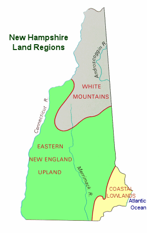
Known for its natural beauty, New Hamsphire features rugged mountains, clear blue lakes, and sandy lake and ocean beaches. All of these features are packed into one of the smallest states of the 50 states. New Hampshire ranks 46th in terms of size; 9,351 square miles. Contained within the Appalachian Highlands, the three primary geological features and landforms (physiographic regions) of New Hampshire are; the Coastal Lowlands, the Eastern New England Upland, and the White Mountain Region.
The Coastal Lowlands
The Coastal Lowlands characterize the southeastern section of the state where New Hampshire borders the Atlantic Ocean. With only 13 miles of coastline, the New Hampshire coastline is shorter than any other state that borders an ocean. The Coastal Lowlands extend from 15 to 20 miles into New Hamsphire. Sandy beaches line the coast and rivers and tidal wetlands extend inland. Great Bay is part of the Coastal Lowlands and thousands of waterfowl stop at the bay during their annual migrations.
The Eastern New England Upland
Most of southern New Hampshire is covered by the Eastern New England Upland, the region that runs from northern Maine south to eastern Connecticut. The New Hampshire section is comprised of 3 distinct areas; the Merrimack Valley, the Hills and Lakes Region, and the Connecticut River Valley.
The Merrimack Valley extends from the Massachusetts border north to central New Hampshire. The Merrimack River runs through this hilly landscape. The soil is fertile and fruits and hay are grown in this region. The valley is also home to New Hampshire's most prominent mill and factory cities and towns.The Hills and Lakes region wraps around the Merrimack Valley region on the east, the north, and the west; from the border of Maine arcing northwest and then south almost reaching the border of Vermont. This area contains most of New Hampshire's major lakes, including its largest; Lake Winnipesaukee.
The Connecticut River Valley extends from north to south along the Connecticut River, New Hampshire's border with Vermont. The lowlands are comprised of fertile farmland and the hills are covered with hardwood forests.
The White Mountains
The White Mountains Region, north of the Eastern New England Upland, covers the northern portion of the state and consists of rugged mountains and narrow valleys. Mount Washington, the highest point in New Hamsphire and the highest point in New England, is part of the Presidential Range. It is 6,288 feet above sea level and home to some of the worst weather in the world. Five other peaks in the Presidential Range are over a mile in height. The Franconia Range includes Profile Mountain which formerly hosted theOld Man of the Mountain, a granite profile of an old man's face, near the peak.
The most northern portion of the region is characterized by heavily forested hills. The western section is populated with dairy and potato farms.
I get some gereral information about New Hampshire
ВідповістиВидалити